The radio transmitter sites are sub-divided according to the type of radio service.
Broadcasting
Presentation of the transmitting stations for FM radio (VHF), short-wave radio (HF), medium-wave radio (MF), digital radio ("Digital Audio Broadcasting" DAB) and television.
The following information is displayed in an information window:
- Name, code:
Station name of the transmitter
- Transmission power (ERP):
Specified in W (ERP = effective radiated power). To determine the total transmitting power of a broadcasting station, the maximum transmitting power of the individual antennas (i.e. all broadcasting antennas at the location in question) is added together, without taking into account the different directions of the antennas. The specified transmission power of a broadcasting station is therefore the maximum value.
- Additional information:
Names and frequencies of the broadcast channels.
Mobile communications
Display of mobile radio base stations.
The following information is displayed in an information window:
Note: Some stations do not yet display the complete information. This will be rectified by June 2024.
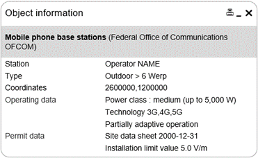
- Station:
Indication of the operator and station name
- Type:
A distinction is made between the following types: "Outdoor > 6 Werp", "Outdoor ≤ 6 Werp", "Indoor ≤ 6 Werp", "Tunnel" and "Temporary station".
Explanation: "Werp" is the effective radiated power in watts.
- Coordinates:
Position of the first mast of a station. A station may consist of other masts (e.g. on the same or a neighbouring roof), which are not shown on the map.
- Operating data:
Classification of the station into power classes (operating transmitting power ERP90)- very low (up to 6 W);
- low (up to 500 W);
- medium (up to 5,000 W);
- high (over 5,000 W).
Stations with transmitting powers of less than 1 Werp are not shown.
Explanation "ERP90": The total transmitting power of a mobile radio station is the transmitting power of the most powerful 90° sector. The actual radiated power is directly dependent on the number of active users. The maximum value is only reached for a short time per day, if at all.
- Technology:
List of the mobile radio technologies used.- 2G: GSM (Global System for Mobile Communications)
- 3G: UMTS (Universal Mobile Telecommunication System)
- 4G: LTE (Long Term Evolution)
- 5G: NR (New Radio)
Due to the technology neutrality of mobile radio licences and construction permits, operators can use technologies that are suitable for the existing terminals.
- Adaptive operation:
- Not specified if the station only operates conventional antenna modules;
- "Partially adaptive operation" if the station operates conventional and adaptive antenna modules
- Permit details:
- "Site data sheet with date" or
- "Due to its low transmitting power, its location or its limited operating time, the installation is not subject to the precautionary limitation of emissions in accordance with NISV Annex 1 No. 64." if the installation is <6Werp, is located in a tunnel or is operated temporarily.
- "Installation limit value" if a site data sheet is available. This field strength (precautionary value) is always complied with everywhere in the vicinity of the station, even under full load.
More detailed information on an individual installation can be obtained from the authorities competent for protection of the environment (canton or municipality).
Last modification 16.04.2024